


Background
In recent years, citizens' expectations of government have changed radically. Current era citizens expect more from government on all levels demanding more information and transparency. They want it faster, and most importantly, in the format and time of their choosing. To accommodate this paradigm shift, cities and local governments are slowly moving away from the traditional ways of citizen engagement to more inclusive, geospatial based mapping technologies to fill the gap.
Problem
One of the leading national planning and engineering consultants were commissioned by Texas Department of Transportation (TxDOT) to perform a Safety Study of a US highway 87 in remote West Texas area that spanned more than 80 miles in length, consisted of half a dozen municipalities with several thousand citizens, and had manifold stakeholders.
Manage Communication
A remote and a long study corridor with multiple municipalities and stakeholders posed a unique logistical challenge to TxDOT and the consulting team to engage constructively for an 18 month long study. With 4 phases in the study, the amount of information to be shared and the level of expected engagement with citizens and stakeholders was extremely time consuming and nearly impossible while holding the public’s interest for an extended period of time.
Buy-in on a long term vision
It seemed difficult to get support for a long-term master plan without knowing the collective public perception of where attention is needed and what actions the public would support. Effective and timely communication was a must to set up a long term vision for the community.
One-Stop Tool
It was extremely difficult to send all the insights to decision-makers involved in the planning-to-action workflow without time delays, data misinterpretation, and with a high degree of accuracy. The client required a platform that can serve both as a two-way communication tool as well as an information exchange tool.
Solutions
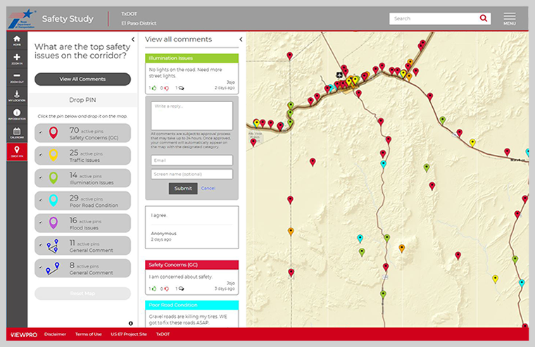
ViewPro’s GeoComment solution was implemented to engage stakeholders and citizens throughout the lifecycle of the project to collect and organize valuable feedback.
GeoComment offers an easy to use user interface and requires minimal or no technical expertise to access the application. It helped the first-time users to get comfortable with the use of technology very quickly and sets up the foundation for on- going participation. All the relevant safety issues are offered in a logical and color coordinated manner inviting users to engage with the application with a single click.
GeoComment solutions is a SAAS (Software-as-a-Service) based platform and hence the cost is distributed among many clients making the GIS based citizen participation an affordable solution to traditional ways of citizen engagement. Due to cost savings, decision makers were able to distribute saved funds to other priority items making the solution affordable on a long term basis.
GeoComment implemented an easy-to-use reporting feature on the backend allowing the administrators to track the incoming comments with ease and curate the conversations on the go. Administrators are allowed to screen through all the incoming comments to avoid unintended and questionable comments before making them public. This enhanced safety feature allows curated comments to flow more efficiently and ensure tough security guidelines provided by the client.
Users can like/dislike and reply to any existing comments posted by other attendees promoting online engagement that is interactive and appealin.
GeoComment works cross-devices, cross-browsers, and is designed with a user interface to suit the requirements of today’s on-the-go generation.
Summary
As Esri’s business partner and GIS innovators, ViewPro was able to provide the TxDOT’s El Paso District with a last-mile solution to solve their unique need to set up an engagement with stakeholders and multiple communities through a single interactive platform for easy, fast, and secured GIS application for Citizen Engagement.